Cape Cod Rail Trail Map & Rider’s Guide
25+ miles of flat, paved path from Yarmouth to Wellfleet — through 7 towns, past ponds, parks, and the National Seashore. Full map, parking info, and how to ride it from our cottages.
📍 Cape Cod Rail Trail Map
Full trail · Mileage & mile markers · Restrooms · Bike shops · Bus stops. Tap to open full size, save it, or print before your ride.
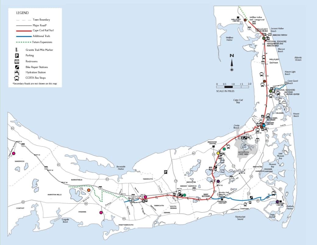
This Cape Cod Rail Trail map shows full mileage and mile markers — save it to your phone or print the PDF before your ride.
📄 Download the Printable Trail Map (PDF)Official Friends of the Cape Cod Rail Trail map & guide — full route, mileage, parking, restrooms & bike shops.
The Cape Cod Rail Trail (CCRT) follows a former railroad line converted into a smooth paved path stretching over 25 miles from Yarmouth to Wellfleet. Use the Cape Cod Rail Trail map above to plan your route by mileage — then ride, walk, run, or rollerblade past state parks, kettle ponds, cranberry bogs, and classic Cape villages.
With rest areas, easy access points, and bike shops all along the route, it’s Cape Cod’s favorite way to spend a day outdoors — for serious riders and first-timers alike.
CCRT north in Harwich — tunnel and rotary heading into Brewster
Two Things That Make This Trail Special
🚇 Bike-only tunnels. Most road crossings are at grade with stop signs for cyclists — but at a few busy roads, the trail dips through dedicated bike tunnels or rises over dedicated overpass bridges so you can keep rolling without stopping for traffic.
🔄 A bike-only rotary. Where the Cape Cod Rail Trail meets the Old Colony Rail Trail in Harwich, there’s an actual traffic roundabout — just for bikes. One of the only ones of its kind anywhere.


Insider Tips for the Ride
Bike Rentals Near the Trail
No bike? No problem — these shops rent traditional bikes, e-bikes, and kids’ gear.
These shops offer traditional bikes, e-bikes, and even gear for kids, making it easy to explore the trail regardless of your experience level.
Free Parking Along the Trail
Free Cape Cod Rail Trail parking is available at well-marked lots all along the route, so you can start your ride from any section — every parking area is shown on the map above.
Note: The Salt Pond Visitors Center lot in Eastham sits about a half-mile from the Locust Road intersection.
Best Stops Along the Way
Riding south to north, don’t miss these:
Nickerson State Park · Brewster
Scenic kettle ponds, wooded trails, and picnic spots right off the trail — the classic rest stop.
Pleasant Lake General Store · Harwich
An old-fashioned store directly on the trail — the favorite refuel spot for snacks and drinks.
Orleans Village
Quaint cafes, ice cream shops, and galleries — a charming lunch break off the path.
Salt Pond Visitors Center · Eastham
Gateway to the National Seashore with pond views, exhibits, and nearby hiking trails.
Cape Cod National Seashore
Ride a little further for the Cape’s best beaches, dunes, and bird-watching.
Getting to the Trail from Our Cottages
Both StandEscapes locations are an easy ride or short drive from a trailhead.
🏖️ Sun of a Beach — West Yarmouth
- By bike: ~20 minutes to the trail entrance at Higgins Crowell Road, South Yarmouth.
- By car: Park free at Old Town House Park, South Yarmouth. Open in Google Maps
🌊 Shore Thing — Dennis Port
- By bike: Head east from the cottages to Depot Road, then north on Depot Road until you reach the trail — a calmer, more bike-friendly route than busy Rt. 134.
- By car: Park at the Rail Trail lot on Rt. 134 and ride from there. Open in Google Maps
Stay Steps from the Trail 🐾
After a day on the Rail Trail, unwind at one of our dog-friendly Cape Cod cottages in Dennis Port and West Yarmouth — hot tub, fire pit, and the beach a short walk away.
Book Your Stay →